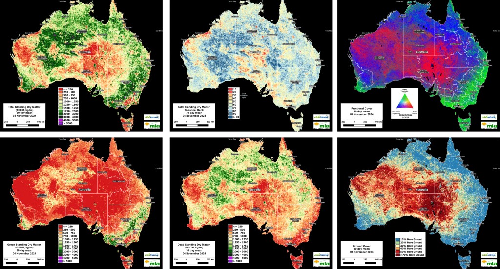
AUSTRALIA’S national feedbase conditions at the end of October 2024 reveal significant regional variations influenced by ongoing drought, rainfall deficiencies, and changes in vegetation cover.
Eastern Australia, particularly in New South Wales and Victoria, has maintained good ground cover and green biomass, supported by recent rainfall, which has led to a slight improvement in feed availability in these areas.
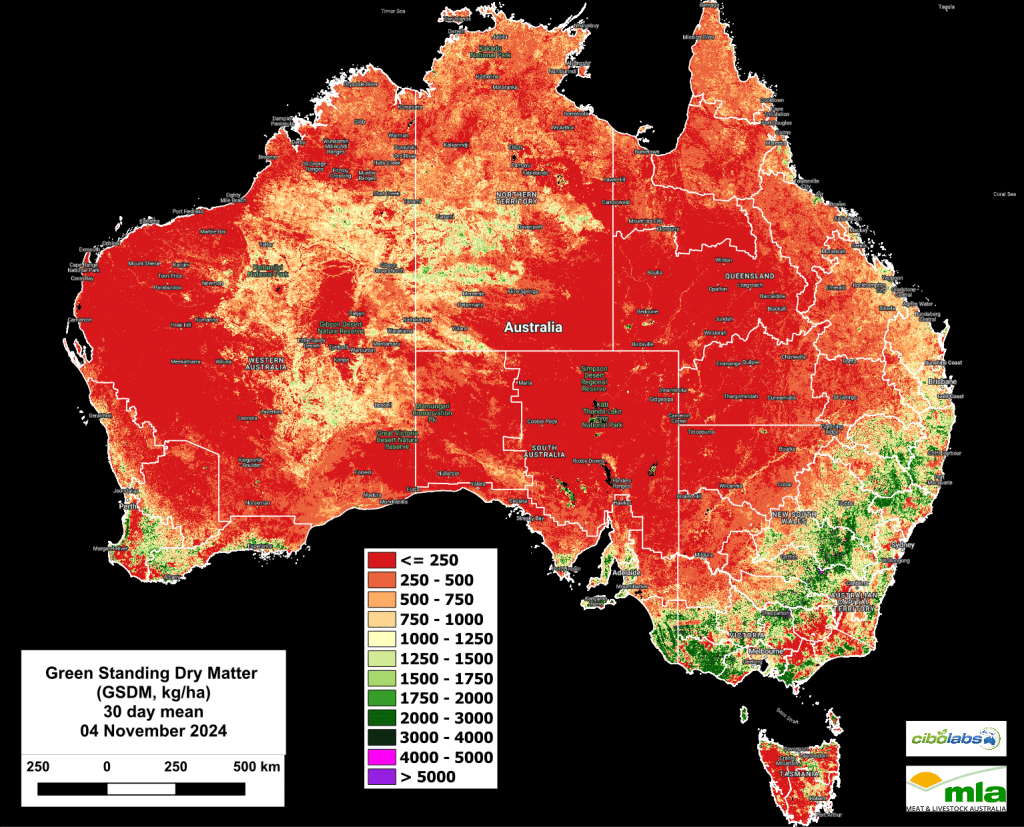
However, much of central and western Australia, as well as parts of Queensland, show extensive bare ground and low green standing dry matter (GSDM), reflecting persistent dry conditions and limited vegetation growth. In southwestern Western Australia, there has been some localized increase in green biomass, but recent dryness has led to an expansion of bare ground in parts of the region.

Imagery and analysis provided by CiboLabs
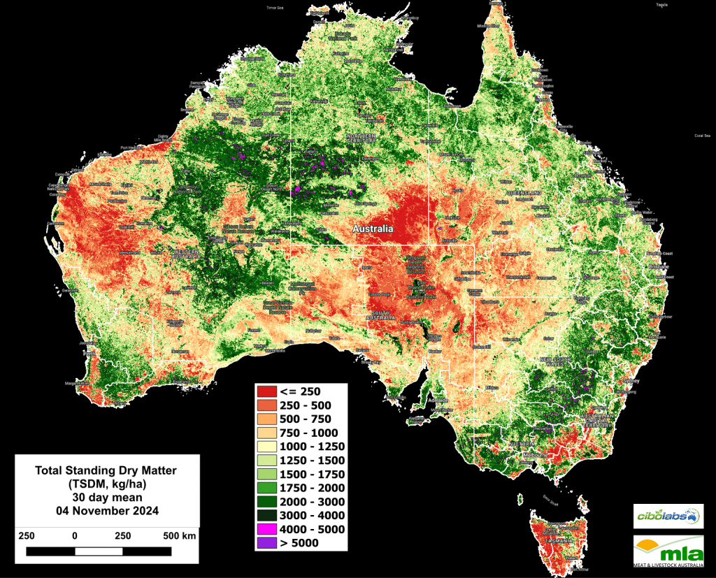
Total Standing Dry Matter
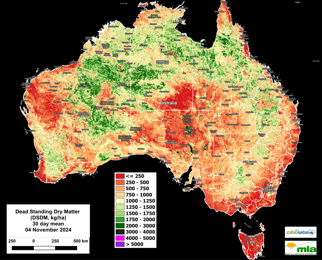
Northern Australia has seen a reduction in dead standing dry matter (DSDM) as green vegetation starts to emerge with the northern wet season’s onset, although some regions still show moderate levels of dead biomass.
Stream flows and water storages remain low across southern and central Queensland and in the west of Western Australia, putting further pressure on available feed resources. Soil moisture levels in southern Australia and western Queensland remain below average, although there has been a slight easing in deficiency severity in some southern areas.
The long-range forecast for the upcoming summer suggests below-average rainfall in western parts of Australia but above-average rainfall in much of eastern Australia, which could help alleviate feed shortages in the east.
Despite this, warmer than average temperatures are likely nationwide, potentially increasing evaporation rates and further stressing water and feed resources.
Overall, the outlook for feed availability remains challenging in many areas, with improving conditions in the southeast but ongoing deficits in central and western regions.
Seasonal Comparison Total Standing Dry Matter
In eastern Australia, especially across Queensland and New South Wales, slight increases in biomass are visible between October and November, with a broader area now exceeding 750 kg/ha of total standing dry matter (TSDM).
This suggests improved forage availability in some eastern regions. In contrast, central Australia continues to show low biomass levels, predominantly below 500 kg/ha, reflecting persistent dry conditions and limited vegetation growth over the period.
Southwestern Western Australia has experienced some expansion in vegetation cover, particularly along coastal areas, with more regions now falling within the 500–1000 kg/ha TSDM range.
This indicates a minor improvement in biomass levels there.
Meanwhile, northern regions, including the Barkly Tablelands and the Gulf, maintain relatively stable biomass levels, showing little change and remaining in moderate-to-low ranges.
Overall, these patterns highlight localized improvements in the east and southwest, while central and northern Australia exhibit limited variation, with central areas remaining especially low in forage availability.
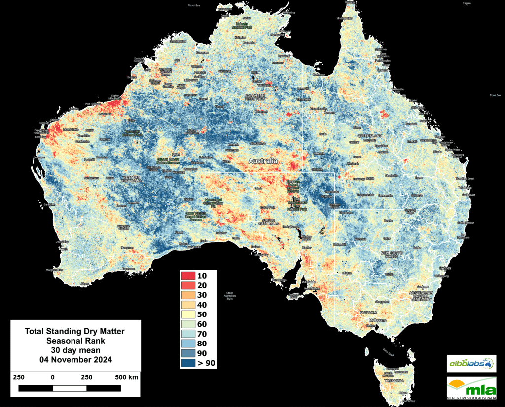
Northern Australia, including areas like the Barkly Tablelands, Gulf, Cape York, and northeast Queensland, maintained relatively stable TSDM levels between October and November, with regions staying in the 40–70 decile range.
While these areas did not show significant change, their conditions remained consistent with typical seasonal patterns, with moderate-to-low biomass.
In contrast, New South Wales, particularly in the eastern regions, saw slight improvements in biomass, with some areas moving into the 50–70 decile range, reflecting a shift toward near-average or slightly above-average TSDM levels.
Central Victoria and Tasmania showed minimal fluctuations, with TSDM levels generally remaining near average.
However, northeast Tasmania and the Bass Strait Islands continued to experience below-average conditions, with little improvement over this period.
Meanwhile, southern Australia, including parts of the Pilbara and Gascoyne regions in WA, has consistently recorded below-average TSDM, reflecting persistent dry conditions that have not shown significant recovery in recent months.
Fractional Cover (Growth)
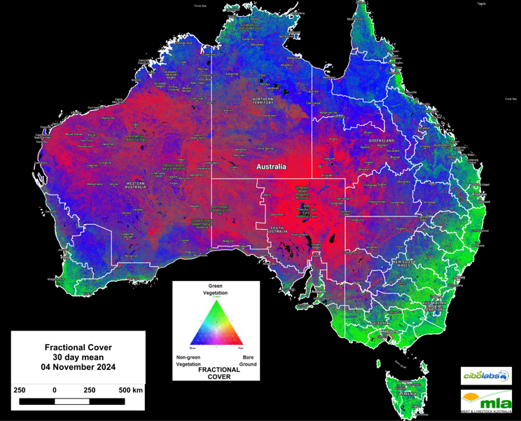
Fractional cover data highlights an increase in green vegetation cover in eastern Australia, particularly across NSW, Victoria, and parts of Queensland, shown as bright green areas on the November map.
This growth is likely to improve biomass levels in these regions, even though some areas still experience below-average TSDM.
In southwestern WA, there is a slight expansion of green cover from Geraldton southeast toward the coast, indicating modest but steady vegetation growth along coastal areas.
The November data also shows a transition from non-green (blue) to green vegetation in parts of these regions, reflecting progressive seasonal growth.
However, central Australia continues to display extensive bare ground, with limited vegetation cover dominated by non-green and bare ground areas, highlighting persistent dry and arid conditions in these zones.
Green Total Standing Dry Matter
Green standing dry matter (GSDM) levels are highest in southeastern Australia, particularly in parts of New South Wales and Victoria, where biomass levels now range between 750 and 1500 kg DM/ha.
This increase is evident from southeastern Queensland through to the southern cropping zones, reflecting recent vegetation growth likely due to seasonal rains.
In southwestern Western Australia, there are localized increases in GSDM, with coastal areas moving into the 250–500 kg DM/ha range, indicating slight improvement in green vegetation cover.
Meanwhile, central and northern Australia continue to exhibit low GSDM levels, predominantly below 250 kg DM/ha, emphasizing persistent dry conditions with minimal vegetation recovery.
Southeastern New South Wales and Tasmania also show moderate biomass concentrations, although these generally remain lower than the main southern cropping zones.
Dead Standing Dry Matter
Dead standing dry matter (DSDM) has decreased across northern Australia, particularly in central Queensland, where DSDM levels have dropped from the 750–2000 kg DM/ha range in October to lower levels (250–500 kg DM/ha) in November.
This reduction suggests a transition from dead to green biomass as vegetation responds to recent rainfall.
In the eastern Kimberley and parts of the Northern Territory, there are still patches of moderate dead biomass, but overall DSDM levels have declined.
In the southern states, including South Australia, Victoria, and Tasmania, DSDM remains sparse, generally below 750 kg DM/ha, with minimal increases observed.
Central Australia continues to show persistently low dead biomass, with levels remaining under 250 kg DM/ha, indicating ongoing arid conditions with limited vegetation recovery.
Southwestern Western Australia shows a localized increase in DSDM, moving into the 500–1000 kg DM/ha range, likely due to the accumulation of dead plant material following a drier period.
Overall, the data suggest a decrease in dead biomass in the north and east, while central and southwestern regions exhibit stable or slightly increased DSDM.
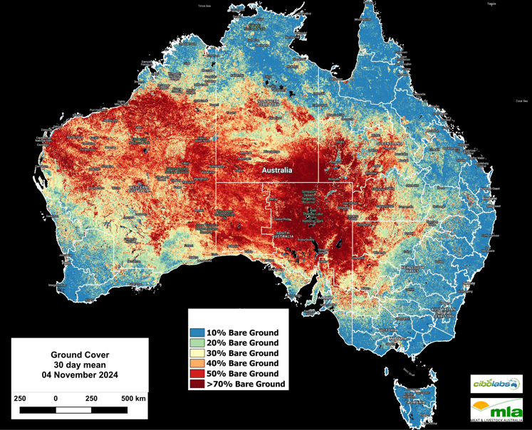
Monthly Ground Cover levels
Ground cover showed regional variability between October and November, with some significant trends in specific areas.
Central and western Australia exhibited an increase in bare ground, with many areas now exceeding 50% bare ground, particularly in the interior regions where exposed soil expanded due to ongoing dry conditions.
Northern Australia, including parts of Queensland and the Northern Territory, showed relatively stable ground cover, although some regions experienced a slight increase in bare ground, moving from the 20%–30% range to 30%–40%.
In contrast, southeastern regions, including New South Wales and Victoria, maintained dense vegetation cover with less than 20% bare ground, reflecting stability and healthy vegetation likely due to recent rainfall.
Southwestern Western Australia displayed a localized increase in bare ground, with some areas shifting from the 10%–20% range to 30%–40%, possibly due to drying conditions after an earlier period of growth.
Overall, the November map indicates an expansion of bare ground in central and western Australia, while southeastern regions retained stable, dense ground cover.
These changes suggest worsening dry conditions in central and western areas, with relatively favourable vegetation stability in the southeast.
For more localised information including regional level overviews, users are encouraged to explore the Cibo Labs Regional Comparison. This tool provides regional data that may show the impact of localised weather or fire events. A further level of detail for individual properties is available for users who have created an Australian Feedbase Monitor account, which can be accessed both through the MyMLA portal or through the Cibo Labs website. These tools enable land managers to make data-informed decisions tailored to their unique feedbase conditions and needs.
The Cibo Labs National Comparison can be used to freely access these layers (https://www.cibolabs.com.au/products/national-comparsion/) to view the most recent images from a national, state or catchment level.
This tool can complement the Australian Feedbase Monitor which can also be created within the Cibo Labs Web Site www.cibolabs.com.au
